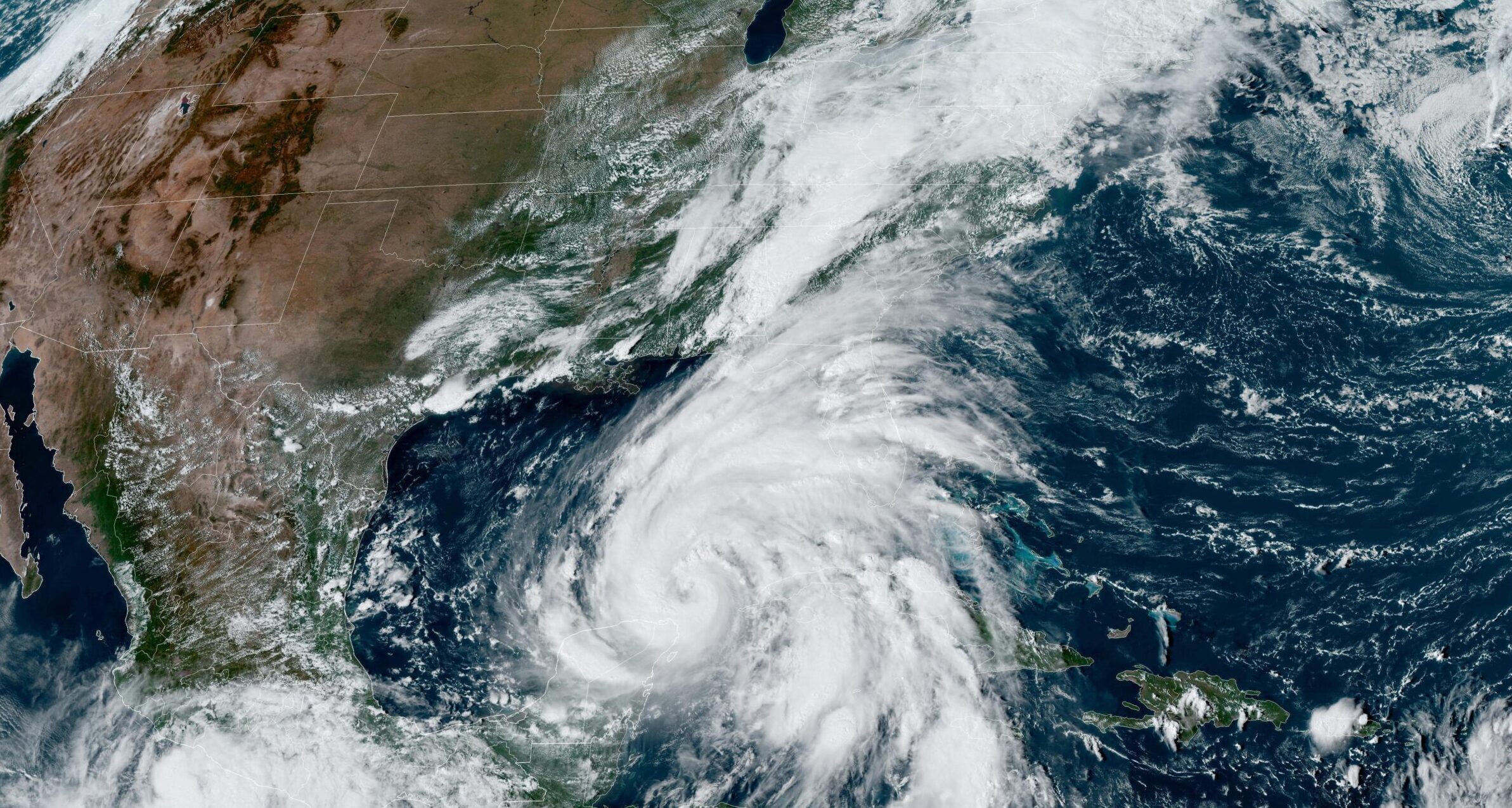
Over the next two days, it struck inland in a North-northeasterly direction, bringing torrential rainfall to a large region including most of Georgia, western North and South Carolina, eastern Tennessee and southern Virginia. This led to extensive and in many cases unprecedented flash flooding across many of these regions. At least 227 people were killed and nearly 2 million were left without power (AP News, 2024; CNN, 2024).
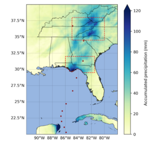
The influence of climate change on tropical cyclones is more complex compared to other types of extreme weather events as impacts are driven by both heavy rainfall and extreme winds. In addition, the surrounding conditions, in particular the sea surface temperatures in the Gulf of Mexico and wider basin, are crucial for the formation of hurricanes. Here, scientists from the United States, the United Kingdom, Sweden and the Netherlands, use several different approaches to investigate the influence of climate change on these different aspects of hurricane Helene, following the same approach as with Typhoon Gaemi that led to severe impacts in the Philippines, Taiwan and Hunan province of China earlier in the year, to analyse whether and to what extent human-induced climate change affected wind speeds and rainfalls associated with Hurricane Helene. For the assessment of the role of climate change in the heavy rainfall, we divide the most impacted region into two subregions, the coastal region encompassing 29.5-32 °N and 81.5-86 °W (figure 1.1) where Helene made landfall and caused 2 days of extreme rainfall, and the inland region, encompassing 34.5-38 °N and 80-85 °W (figure 1.1), in the Southern and Central Appalachians where the rainfall from the hurricane combined with an earlier heavy rainfall system and led to 3 days of unprecedented rainfall. To study the conditions that formed and fuelled Helene, we also analyse the role of climate change in high sea surface temperatures and potential intensity, a metric combining sea surface temperature, air temperature and air humidity data to predict maximum hurricane wind speeds.
Main findings
- Hurricane Helene formed in the Gulf of Mexico above record-hot sea surface temperatures (SSTs). In the days leading up to Helene’s landfall, a line of slow-moving storms formed along a stalled cold front, drawing in tropical moisture from Helene’s outer edges. This system, stretching from Atlanta through the southern Appalachian region, led to very heavy rainfall in the southern states and Appalachia even before the heavy rainfall associated with Helene arrived, leading to devastating flooding. Overall, at least 227 people died, the highest death toll from a hurricane in the mainland US since Katrina in 2005.
- In addition to the very heavy rainfall caused by the hurricane, and the preceding rain event, the steepness of the terrain funnelled rainwater into rivers and streams leading to extremely sudden flash flooding as high as rooftop levels making evacuations impossible in many regions.
- In today’s climate, that has already been warmed by 1.3 °C due primarily to the burning of fossil fuels, weather observations indicate that rainfall events as severe as those brought by hurricane Helene now occur about once every 7 (3 – 25) years in the coastal region, and about once every 70 (20 – 3000) years in the inland region.
- To determine the role of climate change in the rainfall we combine observations with climate models. In both regions, the rainfall was about 10% heavier due to climate change, and equivalently the rainfall totals over the 2-day and 3-day maxima were made about 40% and 70% more likely by climate change, respectively. If the world continues to burn fossil fuels, causing global warming to reach 2 °C above pre industrial levels, devastating rainfall events in both regions will become another 15-25 % more likely.
- The IRIS model was used to investigate Helene’s strong winds by analysing storms making landfall within 2 degrees of Helene. By statistically modelling storms in a 1.3°C cooler climate, this model showed that climate change was responsible for an increase of about 150% in the number of such storms (now once every 53 years on average, up from every 130 years), and equivalently that the maximum wind speeds of similar storms are now about 6.1 m/s (around 11%) more intense.
- The environmental conditions leading to a storm of Helene’s intensity were also studied. Using the same approach as for rainfall, we find that climate change increased the potential intensity in September around the track of Helene increased strongly in likelihood by a factor of 18. Using the Ocean Climate Shift Index, we find that the sea surface temperatures (SSTs) over the track of the storm have been made about 200-500 times more likely due to the burning of fossil fuels.
- Together, these findings show that climate change is enhancing conditions conducive to the most powerful hurricanes like Helene, with more intense rainfall totals and wind speeds. This is in line with other scientific findings that Atlantic tropical cyclones are becoming wetter under climate change and undergoing more rapid intensification.
- Hurricane Helene was very well forecast with the national agency NOAA urging media to warn people of “catastrophic and life-threatening” flooding and landslides across the Southern Appalachians. People in affected coastal regions were asked to evacuate ahead of the landfall of Helene. However, most of the deaths occurred farther inland, in the mountainous terrain where challenges such as spotty cell and internet services, limited experience with Hurricanes and more limited evacuation infrastructure have been reported in the media as leaving people feeling caught off guard.
- Along the inland path of Hurricane Helene a network of dams, and drainage systems exists, that has long been identified as highly exposed to hazards and in a general state of disrepair. A catastrophic dam failure was ultimately avoided, despite evacuations downstream of at least 3 dams warning of potential failure. However, current flood protection infrastructure is not accounting for heavy rain cascading into landslides and mudslides in mountainous regions, as happened in the inland region leading to the destruction of homes, businesses and roads.


