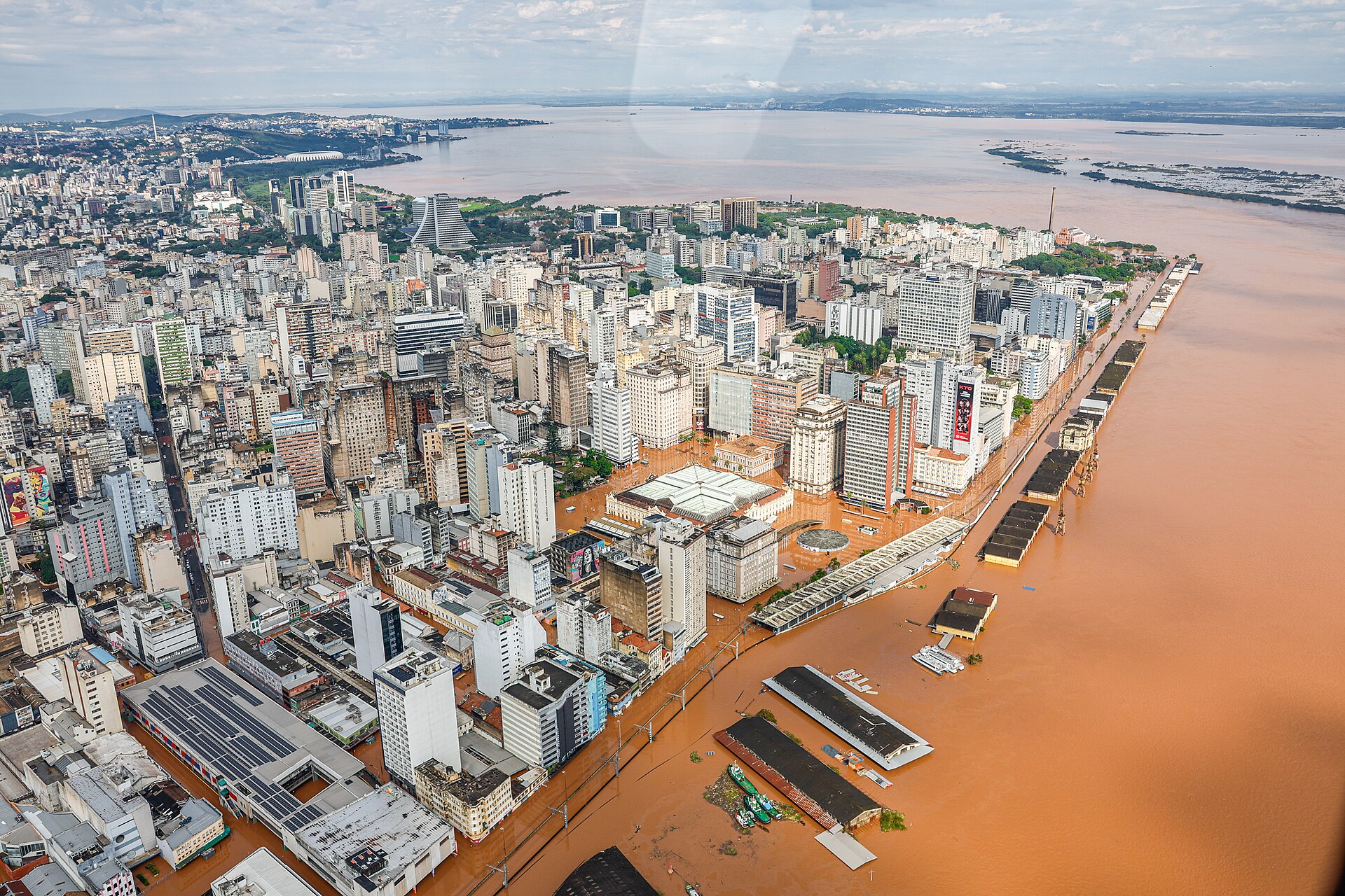
The floods displaced more than 80,000 people, led to over 150,000 being injured and, on the 29th of May, to 169 fatalities with 44 people still missing (Governo do Estado de Rio Grande do Sul, 2024). Essential services were also disrupted, leaving 418,200 households without electricity and over a million consumer units without water. Dozens of municipalities lost telephone and internet services. Municipalities in Rio Grande do Sul that were severely affected by floods, and inundations are classified with risk levels ranging from ‘Medium’ to ‘Very High’ for geo-hydrological disasters on the AdaptaBrasil platform. Cities such as Porto Alegre, Eldorado do Sul, Canoas, Guaíba, Novo Hamburgo, Estrela, and Encantado, for example, are characterised by the highest degrees of Hazard and Exposure.
Researchers from Brazil, the United Kingdom, Sweden, the Netherlands, and the US collaborated to answer the question of whether and to what extent human-induced climate change altered the likelihood and intensity of the rainfall that caused the flooding. They also investigated the role of the El Niño Southern Oscillation (ENSO).
Rainfall in Southern Brazil (comprising the states of Paraná, Santa Catarina, and Rio Grande do Sul) is characterised by a subtropical climate (transition between tropical and temperate climate) with a continuous supply of moisture from the Atlantic Ocean and the Amazon region thus no distinct rainy seasons exist. Rainfall varies from year to year depending on large scale climate phenomena such as ENSO.
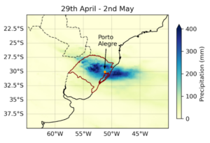
To capture the nature of the extreme rainfall that resulted in extreme flooding across Rio Grande do Sul, two event definitions are analysed in this study: the 4- and 10-day rainfall accumulations, averaged over the state of Rio Grande do Sul. The 4-day window captures the most severe single event in which record rainfall fell across several consecutive days, while the 10-day window (encompassing 26th April – 5th May, inclusive) captures the succession of heavy rainfall events, including the very wet individual days either side of the major 4-day peak (figure 1).

Main findings
- The unprecedented 2024 April-May floods in Rio Grande do Sul have affected over 90% of the state, an area equivalent to the UK, displacing 581,638 people and causing 169 deaths. While Rio Grande do Sul is often perceived as a well-off region, it still has significant pockets of poverty and marginalisation. Low income has been identified as a significant driver of flood impact. Informal settlements, indigenous villages, and predominantly quilombola (descendants of enslaved Africans) communities have been severely impacted.
- The lack of a significant extreme flood event, until recently, in Porto Alegre led to reduced investment, and maintenance of its flood protection system, with the system reportedly beginning to fail at 4.5m of flooding despite its stated capacity to withstand water of 6m. This, in addition to the extreme nature of this event, contributed to the significant impacts of the flood and points to the need to objectively assess risk and strengthen flood infrastructure to be resilient to this and future, even more extreme, floods.
- Both rainfall events characterised above, the 10-day and 4-day events, were found to be extremely rare in the current climate, with return periods of 100-250 years. To increase the statistical stability of the analysis given the relatively short data records, we use the 1 in 100 year event for the analysis in this study. This return period is also typically considered a benchmark for risk analysis.
- The El Niño Southern Oscillation, a naturally occurring climate phenomenon, was found to be important to explain the variability in the observed rainfall, consistent with previous research. Most previous heavy rainfall events in the area occurred during El Niño years.
- The role of El Nino alone is comparably large. In observations, compared to a neutral ENSO phase, the current (December-February) El Niño resulted in a consistent increase across all datasets and for both events: by a factor of 2-3 in likelihood and 4-8% in intensity for the 10-day event, and a factor of 2-5 in likelihood and 3-10% in intensity for the 4-day event.
- To assess the role of human-induced climate change we combine observation-based products and climate models that include the observed ENSO relationship and assess changes in the likelihood and intensity for the 10-day and 4-day heavy rainfall over Rio Grande do Sul and find an increase in likelihood for both events of more than a factor of 2 and intensity increase of 6-9% due to the burning of fossil fuels.
- These findings are corroborated when looking at a climate of 2oC of global warming since pre-industrial times where we find a further increase in likelihood of a factor of 1.3-2.7 and an increase in intensity of about 4% compared to present day. Again results are similar for both event definitions.
- While environmental protection laws exist in Brazil to protect waterways from construction and limit land use changes, they are not consistently applied or enforced, leading to encroachment on flood-prone land and therefore increasing the exposure of people and infrastructure to flood risks.
- Forecasts and warnings of the floods were available nearly a week in advance, but the warning may not have reached all of those at risk, and the public may not have understood the severity of the impacts or known what actions to take in response to the forecasts. It’s imperative to continue to improve the communication of risk that leads to appropriate, life-saving action.


